GOES-16s First Images since Launch
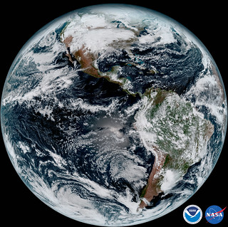
At 1:07 pm EST, January 15, 2017, NOAA/NASA received its first images from GOES-16.

The image shows North and South America and the surrounding oceans. GOES-16 observes Earth from an equatorial view approximately 22,300 miles high, creating full disk images like these from the coast of West Africa, to Guam, and everything in between.
November 19, 2016, a 40-year NOAA/NASA collaborative program launched the next in their series of weather satellites – Geospatial Operational Environmental Satellites (GOES-R).
Once operational later this year [November 2017], GOES-16 will support short-term forecasts, watches and warnings, maritime forecasts, wildfire monitoring, volcanic ash monitoring and space weather predictions.
The National Weather Service and other forecasters using GOES-16 imagery will now have a wide range of uses and societal benefits in areas such as severe weather, energy, transportation and commerce.
GOES-R will improve hurricane tracking and intensity forecasts, increase thunderstorm and tornado warning lead time, improve aviation flight route planning, provide data for long-term climate variability studies, improve solar flare warnings for communications and navigation disruptions, and will enhance space weather monitoring.
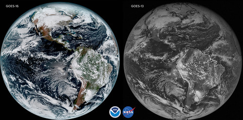
At 22,236 miles above the earth, GOES-16 is right now orbiting the western hemisphere. From its geostationary location, the satellite’s onboard imager, or ABI (Advanced Baseline Imager) collects unprecedented 16 spectral channels (think bands in a rainbow) producing never-before high-resolution pictures; in comparison, its predecessor GOES-13 sported mere five channels.

GOES-16’s ABI instrument, built by Harris Corporation, can multi-task in a way that older satellites cannot. It can provide a full disk image of the Earth every 15 minutes, one of the continental U.S. every five minutes, and has the ability to target regional areas where severe weather, hurricanes, wildfires, volcanic eruptions or other high-impact environmental phenomena are occurring as often as every 30 seconds.
ABI covers the Earth five-times faster than the current generation GOES imagers, and has four-times greater spatial resolution, allowing meteorologists to see smaller features.
The ABI instrument transmits the 1s and 0s through NOAA’s ground system which then translates the data into maps and analysis and makes it available to the international community – the Americas, Europe, Asia, and Africa. Amicable coordination between countries is crucial to the program’s full implementation, improvement, and success.
Working with other nations adheres to NOAA’s principle of open data sharing, allowing other countries to benefit from sophisticated GOES-R satellite data that will help save lives and protect communities through more accurate forecasts.
GOES-16 is more than weather forecasting. It can drastically reduce the precious time between lost and found.
Beginning with GOES-I, the Search and Rescue subsystem has been carried on each of the GOES. Distress signals are broadcast by Emergency Locator Transmitters carried on general aviation aircraft, aboard some marine vessels, and by individuals, such as hikers and climbers.
A dedicated transponder on each GOES detects and relays signals to a Search and Rescue Satellite-Aided Tracking (SARSAT) ground station. GOES-R’s transponder will be able to operate at a lower uplink power than previous GOES transponders, enabling GOES-R to detect weaker beacon signals.
Through a rescue coordination center, help is dispatched to the aircraft, ship, or individual in distress. SARSAT is an international program, with many satellites making up a world-wide network of emergency beacon transponders. Since 1982, SARSAT helped save more than 39,000 lives worlwide.
Between 2018, when GOES-S launches, and 2025 three more satellites are expected to orbit the planet extending the life of the GOES program until 2036.
The -16 will find its forever home in November 2017.
Welcome, RedStaters! You’ve found the company WaterCooler. It’s RedState’s only Daily open thread. Enjoy!


Join the conversation as a VIP Member